
Like many folks, I travel some for work. Typically, most of my trips keep me on the East Coast – sometimes venturing into the mid-west or to Texas. I’d hardly classify any of the places I go as being visually awe-inspiring or “cool”. Not that places like Dallas or St. Louis are bad – they just aren’t as visually compelling as some other parts of the country. Some of my recent trips have broken this mold, though.
Earlier this year, I spent a week in the Sacramento, California area. Sacramento is very close to Napa Valley, so I was able to take an afternoon jaunt over to experience some of wine country.
Several weeks later, I spent time in Tucson, Arizona and Salt Lake City, Utah. Both of these places were tremendously beautiful and unlike any other place I’d been. That being said, my work schedule didn’t allow me to really get out and explore too much. I did have a couple of good runs in Tucson, but wasn’t able to in SLC.
I recently was able to spend a little more than a week in the Seattle area. To say that the PNW is beautiful is a huge understatement. Were it not for the long rainy / gloomy season (basically fall through late spring), I think I’d love to live there.
Forced to spend the weekend in the area, I decided to do some exploring and sightseeing. Saturday afternoon, I drove south to Mt. Rainier – the iconic volcano that on a clear day you can see from Seattle. Like Mt. Saint Helens, Mt. Rainier is a living and active volcano. Although it hasn’t erupted in some time (like since 1894), the potential is that it could blow again. Unfortunately, the weather was not cooperating – it was raining at lower elevations and snowing at higher elevations. You couldn’t really see the mountain at all. I was able to get out and do a little hiking – and surprisingly, there was still quite a lot of snow covering. Even despite not being able to see the top of the peak, the scenery was beautiful and well worth the drive.
Sunday brought beautiful weather – a high in the low 70’s and hardly a cloud in the sky. Thinking it might be a great idea to go for a trail run, I consulted the Almighty for where to go. (I Googled it). The closest place for hiking or running that afforded a good potential to see Mt. Rainier was Tiger Mountain State Forest.
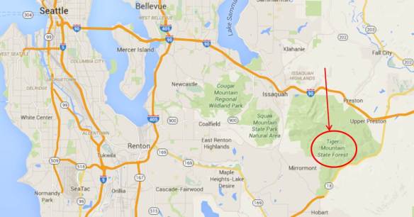
Tiger Mountain State Forest is actually comprised of several peaks – East Tiger Mountain, West Tiger Mountain, Middle Tiger Mountain and Poo Poo Point. Each of the summits and the trails leading too offer different and unique views and challenges, I’m told, but East Tiger Mountain affords the best view of Mt. Rainier on clear days. It also happens to be the tallest of the summits at 3000 feet elevation.
The trail that I took was more gravel road than “real” trail. The mountain is crisscrossed with mountain bike trails, but I didn’t want to get in their way or get creamed by some cyclist who might have lost control, so I thought my route was likely going to be the best choice. The fact that it was a gravel road didn’t make the run any easier.
The first 3.5 miles were essentially all up. The slope varied, of course. There were sections that were really steep and others that were still inclined, but not so leg crushing. Living in Florida, I don’t get the chance to run on hills….ever. This made for a long, painful, slow slog up the mountain. Given the altitude and lack of hill training, I thought my heart was going to explode from my chest.
The summit, though, was amazing. The view opened up towards the south – you could see towards Tacoma and the surrounding area, of course, but the landscape was dominated by the peak I had so wanted to see – Mt. Rainier.
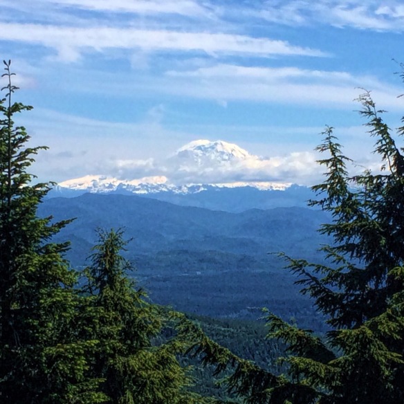
What a sight to behold! The mountain was a good 50 miles or so away, but it looked as if it were literally a short drive away. It was beautiful! Certainly well worth the pain I endured on the run up.
I got a mile or so of ridge running in near the summit, all the while stopping to take more pictures. Finally, I decided I needed to head back down the mountain and call it a day.
As difficult as running 3.5 miles uphill is, running 3.5 miles all downhill is no picnic either. In fact, running down may bring on more quad-busting pain than running up causes. By the time I’d made it back to my car, I was literally out of gas, exhausted, and so, so thirsty (my expert running skills did not compel me to bring a water bottle with me on the run).
Running in the PNW is nothing like running on the East Coast. At least not the Florida coast. The terrain is different, the air is different (there was NO humidity), and the people were different. Literally every person I passed along the trail greeted me, asked me how I was doing and seemed super friendly. This was quite possibly the most difficult run I’ve had in years, but also one of the best, most rewarding runs as well.
